

Foreword by Brad Chambers
Bringing on an intern is an investment of time and energy while offering education and professional development. At GCS Geospatial, an internship is also a hands-on exercise. This summer, we hosted two software development interns; Daniel Schmitz (recent graduate of Saint John’s University) and Victor Ma (senior at St. Olaf College). Their assignment was not a fictional problem, but a real-world challenge: building a cloud-native platform to streamline and modernize an existing internal workflow for Independent Verification & Validation of geospatial data.
Students often approach tasks without preconceived notions or limiting beliefs which can sometimes be present in even the most seasoned professionals. They inject new ideas, fresh perspectives, and outside-the-box thinking to solve problems. We challenged our interns to reimagine what began as a tedious and manual data review process and develop it into an interactive web application deployed to AWS cloud. Each intern was new to GIS and AWS, and both demonstrated an ability to quickly learn new technology by translating those skills into a practical and valuable solution for our company and our customers. Demonstrations of their solution netted positive comments from colleagues and accolades for how much the interns accomplished in a short amount of time. Successfully developing a web application, they called the Geospatial Information Platform (GIP), proved a win-win for both interns and company. Interns received mentorship and hands-on experience, and GCS benefited from new efficiencies that will increase productivity on future projects.
At GCS Geospatial, an internship is a hands-on exercise for real-world challenges.
In the following post, Daniel articulates his experience as an intern with GCS Geospatial and explains how the web application was developed.
2025 Internship Project and Experience by Daniel Schmitz
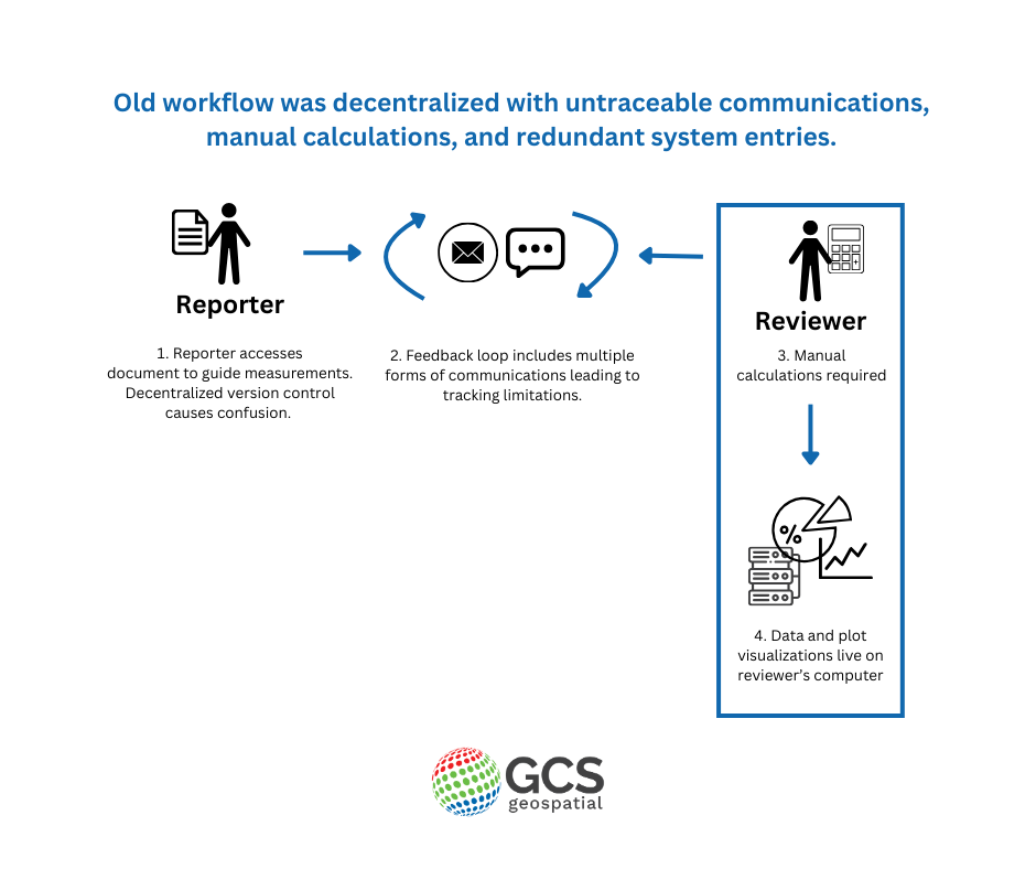
The Challenge
During our summer internship, we were asked to create a cloud-native workflow with an enhanced interactive experience to streamline and improve the existing review process. The legacy process included many redundancies and ad hoc communications that were difficult to track. Additionally, each edit required manual recalculations that took a lot of time.
Interns were challenged to build a cloud-native platform to streamline and modernize an existing workflow.
The Solution
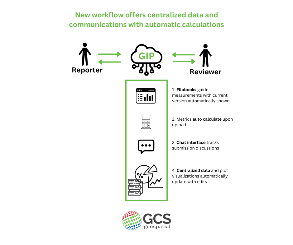
We set out to transform the existing workflow into a single web application by utilizing the full capabilities of the tools at hand. Django, a Python framework, was selected because it offered the necessary flexibility. htmx allowed for the reactive feel of a modern page and optimized loading times. The combination of a PostgreSQL database and the PostGIS extension created space to store complex geometric data necessary for geospatial data analysis. Plotly was used for visualization and mapping needs. These tools, plus quick learning about GIS data and AWS technologies, made development possible.
By the end of the internship, we had developed a working and streamlined web app appropriately named Geospatial Information Platform (GIP). Additionally, we’d built several CI/CD pipelines for deploying the web app to AWS cloud using ECS, ECR and an ALB, and used S3 and RDS for storage.
GIP combines multiple web apps into one making interactive tools, automatic calculations and easy communications between teams available in a central location. The main sections are:
- Flipbooks – a set of points that have images and rough coordinates for use by the reporters to collect data
- Data Visualization Dashboard – a set of charts and metrics for validating and viewing the reports uploaded by users
- Upload – the interface for users to upload collected data; a few metric values are calculated as soon as the data is submitted
- Chats – a centralized and unified conversation between reporter and reviewer, directly related to the specified report
- System – an abstracted admin management panel; it gives soft permissions to the admins, allowing them to activate and manage flipbooks, points, users, reports, and other necessary resources
There remains room for app improvement including addressing outstanding issues, browser security and permissions, and adding notifications.
Intern Experience
Interning with GCS was both fun and educational with opportunities to work through problems, have conversations, and find solutions. I gained experience with AWS, htmx, advanced Django features, and improved knowledge of Docker, security practices, performance optimization, and other technical skills useful for future projects. GCS also exposed me to non-coding technical opportunities and offered first-hand experience conducting GNSS surveys, gathering data, and coached me on what geospatial information is used for and why it matters. Some of the best times of the internship included conducting the survey, flying and watching the drone, and getting the chance to build something from the ground up. I am most proud of the app we delivered and am looking forward to applying what I’ve learned here at GCS Geospatial to future opportunities.
The best part of my internship experience was the chance to build something from the ground up. – Daniel Schmitz, Intern
If you or someone you know is interested in working with GCS Geospatial, check back regularly to see all open positions and future internship opportunities.